File not found.

The villages of Zagoria are uniquely endowed with extraordinary natural beauty, a vast temperate forest ecosystem, distinctive architecture, cultural wealth and the sheer romance of an ancient way of life. From the Slavic word meaning "behind the mountains," Zagoria is defined by the Gamila (Tymfi) and Mitsikeli Mountains as well as the Aoos River. It is a part of the massive Pindus Mountain Range that stretches from Albania to Central Greece.
Zagorians
The history of Zagorians is shrouded in the distant past. Ancient tribes
known collectively as Pelasgians inhabited the area between 2500BC and
2000BC. Old Pelasgic walls have been found in Vitsa, Asprangeli and Skamneli.
Little is known about their descendants, the pastoral tribes who lived
here from 2000BC to 800BC. Corinthian colonists settled in along the coast
of Epirus between 800BC and 600BC but it was not until the 5th century
BC that King Tharypas united the Epirote tribes and encouraged the culture
of the southern Greeks.
A small number of Vlach and Sarakatsani shepherds still practice the dhiava, an ancient tradition of moving their sheep to higher grazing grounds in the summer. The semi-nomadic Vlachs live in villages close to their mountain pastures including some of the villages of Eastern Zagoria. They are of uncertain origin but their language is similar to Romanian and Italian. The Sarakatsani were a nomadic people with no established homes. Today, they live in scattered communities although some Sarakatsani have remained shepherds and still maintain the old customs. Unlike the Vlachs who mingled freely with the Slavs and Bulgars, the Sarakatsani are thought to be among the purest Greeks and descendants of the original pastoral tribes of Homeric Greece. Their annual festival is held at Gyftokambos in Central Zagoria on the first weekend in August.
Architecture
Nestled into the forests on the sides of precipitous mountains, Zagorians
prospered during the occupation of the Ottoman Turks because their inaccessibility
allowed them to live autonomously. Some became traders and established
trade routes through the Balkans to cities as far away as Vienna, Bucharest
and Odessa. They constructed an extensive system of pathways to accommodate
their mule caravans. Along the road to Vradeto, you can glimpse the Skala
of Vradeto as it winds its way steeply up a cliff. It is an old cobbled
footpath from Tsepelovo that passes through a gorge and until recently,
it was the only access to the village of Vradeto.
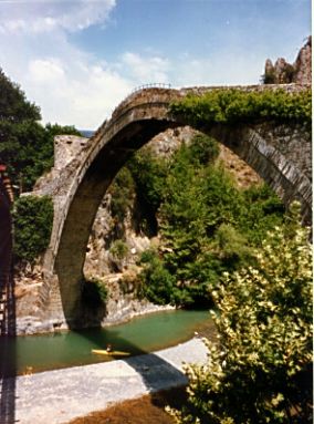
Many rivers flow through the Pindus Mountains and in spring, the melting snow made them dangerous to ford. Bridges were essential for keeping trade routes open and Zagoria is uniquely blessed with these graceful, stone structures. There are many lovely, single-arched bridges but the Kalogeriko Bridge near Kipi is especially beautiful with three arches. These old bridges are very narrow and only a low ridge marks their edges. A small bell hung under them to warn travelers of strong winds that could easily toss a man into the angry torrents.
The Zagorohoria is best known for its traditional villages with their
stone buildings, slate roofs and cobbled paths, all constructed with local
stone. At first glance, the simple, austere structures look alike except
for differences in size. The similarity ends, however, when you step across
the threshold of a house. They are often exquisitely decorated with frescoes,
painted cupboards and elaborate wooden carvings on the ceilings. Some of
the loveliest two-story mansions are found in Papingo and Monodendri, entire
villages which have been declared as national historical monuments. Also
of interest are the 18th and 19th Century folk paintings that decorate
some of the houses in Skamneli.
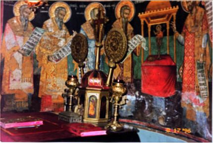
The villages of the northern mountains of Greece were largely responsible for maintaining the Greek heritage during centuries of foreign occupation. The prosperity of Zagoria under the Turks allowed the culture to flourish and found its expression in the numerous churches and monasteries of the region. Churches were built in the style of basilicas and are characterized by low colonnaded arcades on the sides as well as beautiful frescoes and intricately carved wooden altar screens. Many villages have a church and usually a nearby monastery. One of the most delightful churches is found in Tsepelovo. Some years ago, a wealthy patron provided the funds to have the three hundred year old frescoes cleaned of candle smoke and grime. To everyones surprise, they remain rich and vibrant in color and are considered to be among the best preserved in all of Greece.
The Gamila Massif
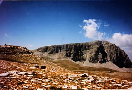 Resembling the Alps rather than
other Greek mountains, the Gamila massif towers over the Aoos ravine to
its north and the Vikos Gorge to its west. It is its western face with
spectacular views of the Pyrgoi (Towers) of Papingo and the unforgettable
grandeur of the Vikos Gorge that makes the villages of Megalo Papingo and
Mikro Papingo a favorite destination in Zagoria. To the south, the Gamila
Mountains descend more gradually to a large tableland that ends abruptly
as it plunges down into deep ravines. In the summer, shepherds tend their
sheep on this high, grassy plateau. It is a desolate land and unlike the
European Alps, there are no picturesque Alpine villages in the valleys
below or even the general bustle of well trodden trails. In this wide open
space, the absence of lifes usual stimuli sharpens your senses and with
an altered consciousness, endows you with the joy of living each moment.
There is a boundless silence and only the distant bark of a sheep dog or
the sound of falling rocks intrudes on the utter stillness. The rugged
terrain unfolds its beauty slowly and gently for those who pass through
in the same way. Majestic peaks soar above you with a timeless air of watchfulness.
Clouds saunter across crisp, blue skies while cooling breezes refresh you
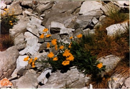
even on the warmest summer day. The rocky places are guardians of tiny,
boldly colored flowers that beckon to the honey bees. Pure mountain water
drips from rocks and small tarns invite you to gaze on the reflected splendor
that surrounds you. It is impossible to tread these ancient, solitary paths
without reflection and one can appreciate why wise Zagorians say that Greeks
discover their true essence in these mountains.
Resembling the Alps rather than
other Greek mountains, the Gamila massif towers over the Aoos ravine to
its north and the Vikos Gorge to its west. It is its western face with
spectacular views of the Pyrgoi (Towers) of Papingo and the unforgettable
grandeur of the Vikos Gorge that makes the villages of Megalo Papingo and
Mikro Papingo a favorite destination in Zagoria. To the south, the Gamila
Mountains descend more gradually to a large tableland that ends abruptly
as it plunges down into deep ravines. In the summer, shepherds tend their
sheep on this high, grassy plateau. It is a desolate land and unlike the
European Alps, there are no picturesque Alpine villages in the valleys
below or even the general bustle of well trodden trails. In this wide open
space, the absence of lifes usual stimuli sharpens your senses and with
an altered consciousness, endows you with the joy of living each moment.
There is a boundless silence and only the distant bark of a sheep dog or
the sound of falling rocks intrudes on the utter stillness. The rugged
terrain unfolds its beauty slowly and gently for those who pass through
in the same way. Majestic peaks soar above you with a timeless air of watchfulness.
Clouds saunter across crisp, blue skies while cooling breezes refresh you
even on the warmest summer day. The rocky places are guardians of tiny,
boldly colored flowers that beckon to the honey bees. Pure mountain water
drips from rocks and small tarns invite you to gaze on the reflected splendor
that surrounds you. It is impossible to tread these ancient, solitary paths
without reflection and one can appreciate why wise Zagorians say that Greeks
discover their true essence in these mountains.
The Vikos-Aoos National Park
 Remnants of the ancient European
forests survive only in Greece, Finland and Sweden, the three most densely
forested countries in Europe. Unlike the Fenno-Scandia forests which are
mainly coniferous forests, the extensive forests of Northern Greece are
comprised of mixed forests with the widest diversity of highland trees
in all of Europe. The Vikos-Aoos National Park is a part Greeces unique
patrimony and was established to protect the rare and threatened flora
and fauna of the region. The Aoos Ravine and the Vikos Gorge mark its boundaries
which roughly encompass Western Zagoria and parts of Central Zagoria.
Remnants of the ancient European
forests survive only in Greece, Finland and Sweden, the three most densely
forested countries in Europe. Unlike the Fenno-Scandia forests which are
mainly coniferous forests, the extensive forests of Northern Greece are
comprised of mixed forests with the widest diversity of highland trees
in all of Europe. The Vikos-Aoos National Park is a part Greeces unique
patrimony and was established to protect the rare and threatened flora
and fauna of the region. The Aoos Ravine and the Vikos Gorge mark its boundaries
which roughly encompass Western Zagoria and parts of Central Zagoria.
The forests of the Aoos Ravine are beautiful, especially in the autumn when the land is emblazoned with color. The brown bear (Ursos arctos) and the lynx (Lynx pardinus), two of the most endangered species, are found here. The forest habitat is essential to their survival. Wild boar (Sus scrofa), the wolf (Canis lupus) and the roe deer (Capreolous capreolous) also live in these forests while high on the surrounding cliffs, chamois (Rupicarpa rupicarpa balancanica)graze and eagles and vultures make their nests. A popular route for exploring the Aoos Ravine is to follow the marked trail from the Konitsa bridge to the Moni Stomiou (Stomiou Monastery). The return trip takes about 5-6 hours making it one of the shortest and easiest unguided walks to be undertaken in Zagoria. Lengthier and much more strenuous approaches can be made from the Gamila refuge on the Astraka saddle (8 hrs.) or from the village of Vrissohori.
The Vikos Gorge can be viewed for most of its length from the Balkoni tou Vikou (Vikos Balcony). This breathtaking view is well worth the half an hour car ride from Monodendri through deciduous forests and past layered rocks of gray-colored flysch that characterize the villages of Zagoria. A trail from Monodendri descends to the bottom of the gorge and follows the course of the Vikos river through thick forests where beautiful wildflowers and medicinal herbs grow in abundance. About half way, the smaller Mega Lakko ravine intersects the gorge and it is in this part of the surrounding forest that the Greek brown bear may also be found. After about 10 km, the trail emerges from the confine of sheer cliff walls to the Voidomatis Springs (about 6 hrs.) from which the trail forks leading to the villages of Vikos (about ? hr.) and Mikro Papingo (about 2 hrs.).
Several peaks of the Gamila Mountains and their seemingly barren upper slopes are included within the borders of the Vikos-Aoos National Park. Legends tell of two dragons who lived in lakes on the mountains of Gamila and Smokilas. The lakes are named after the quarrelsome duo, Drakolimni (Dragon Lake) of Gamila and Drakolimni of Smokilas. They are said to have hurled rocks and trees at each other across the Aoos Ravine and their descendants are supposedly the rare alpine newts (Triturus alpestris) that live in these lakes. In this alpine zone above the forests where even the grassy meadows have begun to dwindle, a significant collection of wildflowers, some indigenous to the Gamila Massif, are found. The highest peak is Gamila (2,497 m.) and in spite of the perpendicular rock wall of its northern face that overlooks the Aoos Ravine, it is possible to make this ascent on foot. There are several trails up the mountain that converge at the base of the peak. The most challenging is the route from Vrissohori via the village of Neraydovrissi and the Karteros Pass. It is arguably one of the most beautiful climbs in all of Greece, not only for its spectacular vistas but also because it passes through every highland zone with an astonishing diversity of trees, shrubs and flowers.
Best Times to Go: Spring arrives late in Zagoria so the middle of April to June offers hikers the most impressive spectacle of profuse wildflowers, full, frothy streams and a wonderland of greenery. Tender blades of soft, fresh grass contrast with the translucence of newly emerging leaves and the strong, dark greens of the firs and pines. In early spring, there is still snow on the ground and temperatures are quite cool. The snow is usually gone by June making it a safer month for exploring the Gamila Massif. July and August are also rewarding because many alpine flowers are in bloom at this time. However, flies are numerous and annoying when passing through the pastures where the sheep graze. September and October are generally more pleasant and the fall colors are exceptionally lovely.
July and August are better for those who are more interested in the cultural aspect of Zagoria. Days are warm and evenings are cool. Zagorians celebrate during these warmer months and the main festival of the season takes place from August 15th to the 18th. Generally, the festivals are famous for their songs and dances and merrymaking often lasts until the early morning hours. Each town has its own unique traditions. In Tsepelovo, the festival is concluded with the young people (for only they have the stamina to party for three days straight) jumping into the spring at the edge of town and returning to the square for a final dance.
Getting There: The most convenient way to visit Zagoria is by car. Cars may be rented in Ioannina, Thessaloniki and Athens but general availability and the best values are to be found in Athens. From Athens, take the National Highway to Larissa. An excellent primary road takes you west from Larissa to Ioannina via Trikala and over the Katara Pass. This portion is an interesting and scenic drive that takes you past the famous monasteries of Meteora and through gorgeous mountain landscapes. Most of the access roads to Zagoria are located between Metsovo and Konitsa along the main highway from Ioannina to Kastoria.
Ioannina is the nearest destination for bus and air service from major Greek cities. If you plan to rent a car here, make advanced reservations because availability is limited, especially in the month of August when most Greeks take their vacations. There are daily local buses from Ioannina to the villages of Papingo, Monodendri and Tsepelovo as well as the many villages along the way. A few small Zagorian villages are still accessed only by footpaths.
Clothing/Gear: Clothing requirements are seasonal. Summer evenings are usually cool so bring a sweater or light jacket. Good walking shoes are recommended for the uneven cobbled paths of the villages.
Hikers require a comfortable day pack, water bottles, good maps, a compass and sturdy hiking boots when trekking in these remote, rugged mountains. Collapsible ski poles or at least a strong stick should be carried as protection against the ferocious sheep dogs that you are likely to encounter as you pass through the highland pastures. Great distances make camping gear necessary for any serious exploration of the Gamila Massif. Provisions and supplies should be purchased in Ioannina as they may be unavailable in the villages.
General Information: Room reservations are unnecessary in the Zagorohoria unless you are planning to visit at festival time, August 15th to 18th. The Greek National Tourist Organization produces a brochure titled "Epirus" which lists a number of hotels in the larger villages and their telephone numbers. However, you only have to locate the main square, the plateia, and ask for a room. You will be directed to the nearest hotel, pension or domatia. Rooms are clean and comfortable and cost about $30-$40 for a double. Meals may be arranged with your host or at the village taverna. Zagoria offers one of the best values in Greece where you can visit and explore the mountain villages for about $25 per person per day for food, lodging and local transportation. A rental car and/or a mountain guide will add to the daily cost but is quite reasonable when shared with a group of 4.
Hiking in Zagoria is strenuous. Most trails up the Gamila Massif are steep and lengthy. It is a good idea to break up your trek with visits to the nearby villages. Using the Gamila refuge as a base, you can hike to Drakolimni of Gamila, climb to the peaks of Gamila and Astraka and explore the Mega Lakko Ravine. Arrangements for use of the refuge must be made at the EOS office in Megalo Papingo (Tel. 30-653-41-138) or through the EOS representative in Mikro Papingo (Tel. 30-653-41-257). They will also provide information and maps.
Do's and Don'ts:
- Do plan your itinerary to include the nearby archaeological site of Dodoni, one of the oldest settlements in Greece dating back to 2500 BC and the site of an ancient oracle.
- Do make the time to visit the Valia Calda (Warm Valley) National Park. It is located midway between Vovoussa in Eastern Zagoria and the village of Milia near Metsovo. It is a paradisaical valley surrounded by the peaks of the Ligkos Mountains and heavily forested with pine and beech trees. There are beautiful stands of Scots pine (Pinus silvestris) and the Valia Calda marks their southernmost range in all of Europe.
- Do stay clear of sheepfolds and flocks of sheep when hiking. Inevitably, there will be fierce sheep dogs nearby. Local people say that they become friendly when you sit on your haunches but it is difficult to assume such a vulnerable posture in the presence of these huge, snarling, spike collared dogs.
- Do use a guide, especially when hiking in remote, forested areas or the less popular trails. Trails are not always well marked and it is very easy to become lost. Be sure to notify someone of your intended itinerary before setting off into the mountains.
- Do attempt to meet Zagorians. Many speak other languages and you will find them to be some of the friendliest people in the world. In Zagoria, you will not find the cynicism that sometimes accompanies tourism. Here, visitors are still treated as welcomed guests.
- Do be forewarned that Zagoria is a place of enchantment. Your visit will always be too brief and you will yearn to return. It is a land where time seems to stand still, where life is still entwined with nature and people treat each other with honor and kindness.
- Hotel Gouris
- The Mountains of Greece by George Sfikas is an excellent resource on mountain climbing in Greece. It provides trail descriptions, maps and interesting aspects of history, mythology and folk poetry as they relate to the mountains. It is available in English at the Compendium Bookshop at Nikis 28, near Syntagma Square in Athens.
- Greece: The Rough Guide by Mark Ellingham, Marc Dubin, Natania Jansz and John Fisher has a good balance of practical and factual information about Greece. The various hiking routes in the northern Pindus Mountains are nicely described.
- Trekking in Greece by Marc Dubin and published by Lonely Planet provides detailed trail descriptions and maps. This is a good resource if you plan to do a lot of trekking in Greece. However, it should be used as an adjunct to their main Greece guide listed below.
- Greece: A Lonely Planet Travel Survival Kit by David Willett, Rosemary Hall, Paul Hellander and Kerry Kenihan provides excellent general travel information on Greece. We particularly like the insights that are highlighted against a blue background.
- Flowers of Greece and the Aegean by Anthony Huxley and William Taylor is a delightful book for those who are fascinated with the extensive variety of flowers to be found in Greece. Particularly interesting is the chapter that describes the flora of the mountains. It may be ordered through its publisher, The Hogarth Press, 30 Bedford Square, London WC1B 3SG.
- The Unwritten Places by Tim Salmon describes his solitary wandering of ancient mule paths and summer pastures in the Pindus Mountains. It tells of his participation in the traditional transhumance (movement of animals to summer pastures) with a family of Vlach shepherds with fascinating insight to a way of life that is rapidly disappearing. It may be ordered through the publisher, Lycabettus Press, PO Box 17091, Athens 100 24, Greece. Tel 30 -1 - 647-1788 Fax 30-1-671-0666.
- Hellas: A Portrait of Greece by Nicholas Gage offers an intimately personal introduction to Greece. It is a fascinating book that should be read by every visitor to Greece. Born in Lia, a village in the Mourgana mountain range near the Albanian border, Mr. Gage devotes an entire chapter to Epirus, the area in which Zagoria is located.
Tsepelovo Ioannina
Greece
Tel: 30-653-81214, 81288
Mr. Alexis Gouris is the proprietor of the Hotel Gouris and the general store on the town square. He is a helpful and friendly gentleman who speaks excellent English and will gladly share his extensive knowledge of Zagoria. He is also the custodian of the keys to the beautiful, little church in Tsepelovo. Mention Adventures Great and Small for an all inclusive price of US$50 per person per day which assumes double occupancy and includes a room with private bathroom, all meals and a personal guide.
Related Books:
